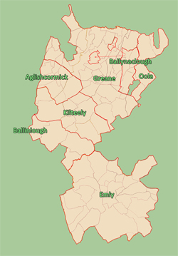
PARISHES IN WHICH THE O'DEA FAMILIES LIVED

Click to enlarge
After the Anglo-Norman invasion, England gradually imposed its own definition of Parish on Ireland--the Civil Parish. At first, these Civil Parishes were exactly the same as the old ecclesiastical Parishes in Ireland. "In England, a civil parish is a territorial designation which is the lowest tier of local government below districts and counties, or their combined form, the unitary authority. It is an administrative parish, in contrast to an ecclesiastical parish." In Ireland, over time the boundaries of these Civil Parishes began to change while the ecclesiastical Parishes upon which they were founded remained the same.
After the Down Survey in 1655/56, "Parishes were delineated...as an intermediate subdivision, with multiple townlands per parish and multiple parishes per barony. On this site, we generally use the term "Parish" in this sense of the word.
 In 1850, Samuel Lewis published his Topographical Dictionary of Ireland in which he provided historical and statistical descriptions of the various counties, cities, boroughs, parish and villages in Ireland. A few years earlier, Richard John Griffith was appointed by the British Government to conduct a boundary survey of Ireland in order to determine who was in possession of Irish land and how much each of these persons owed the Church of Ireland in tithes. In conjunction with this task, he created a set of detailed maps of Ireland which showed the boundaries of baronies, parishes and townlands. Together these two works provide an invaluable tool for people who are interested in Ireland between 1826 and 1850.